What Is Point Cloud to CAD and When Do You Need It?
How LiDAR and scan data become usable CAD drawings, and the projects where it pays off.
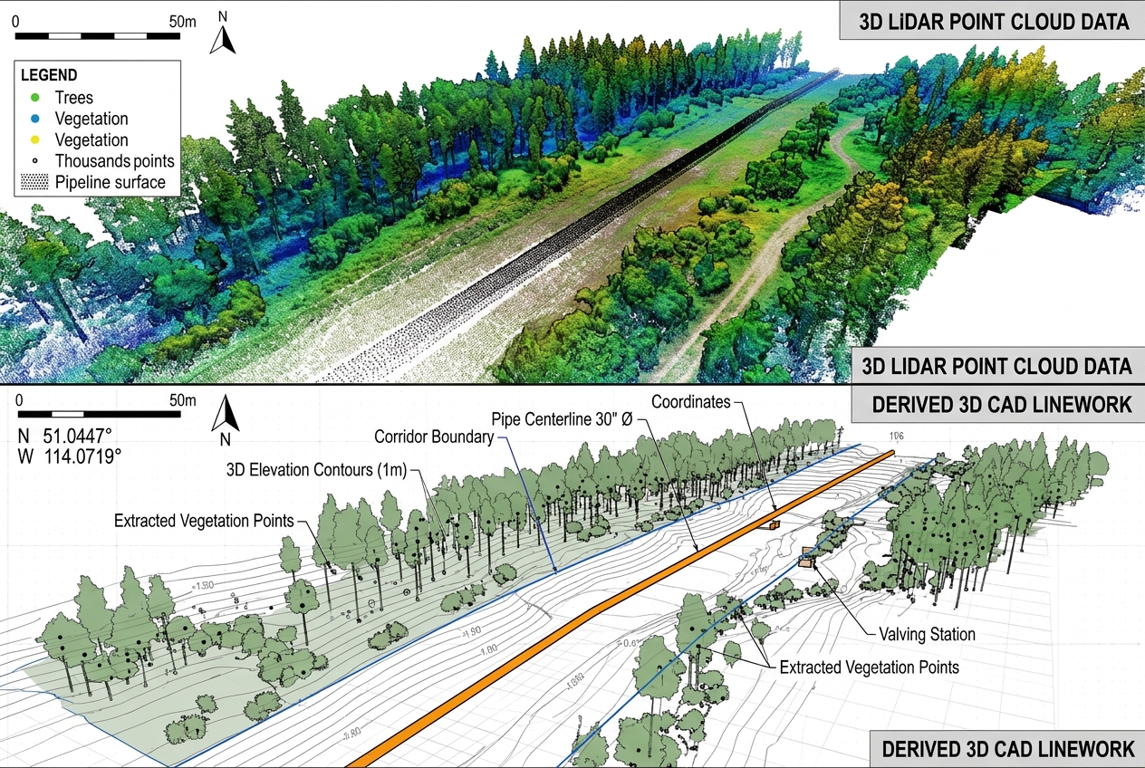
Laser scanners, mobile LiDAR and drones capture millions of points in hours. But a point cloud is not a deliverable. Engineers, architects and clients need clean CAD linework, surfaces and drawings.
What point cloud to CAD means
It is the process of classifying, cleaning and extracting features from scan data to produce 2D drawings and 3D models: ground surfaces, contours, building outlines, kerbs, utilities, floor plans and elevations.
Common data sources
- Terrestrial laser scanning – buildings, plants and detailed site features.
- Mobile LiDAR – road and pipeline corridors.
- Aerial and drone LiDAR – large topographic areas, mines and forestry.
- Drone photogrammetry – dense surfaces and orthophotos.
When it is worth it
- Large or hazardous sites where traditional shots are slow or unsafe.
- Corridor projects spanning many kilometres or miles.
- Existing buildings needing measured floor plans and elevations.
- Stockpile and earthwork volume reporting.
Typical deliverables
- Bare-earth TIN surface and contours.
- Planimetric CAD of all visible features.
- Floor plans, sections and elevations.
- Volume reports.
The point cloud to CAD workflow
1. Data review
We check registration, coverage and density, and confirm the coordinate system and units with you.
2. Classification and cleaning
Noise, vehicles, people and vegetation are removed or classified so ground points can be isolated.
3. Surface creation
A bare-earth TIN is generated from ground points, with breaklines added along kerbs, walls and changes in grade.
4. Feature extraction
Buildings, kerbs, edges of pavement, poles, manholes and other features are traced into CAD linework on your layers.
5. Drafting and annotation
Sheets are laid out on your template with levels, contours, labels and notes, ready for surveyor review.
Point cloud vs traditional survey
- Speed in the field – scanners capture a site in hours instead of days.
- Completeness – everything visible is captured, so return visits for missed features are rare.
- Safety – roads, rail and industrial sites can be surveyed with less exposure.
- Office effort – processing takes skill, which is why many firms outsource it.
Industries that rely on scan to CAD
Architecture and building renovation, transport corridors, mining and quarrying, utilities and pipelines, and heritage documentation all benefit from accurate drawings created from scan data.
Tips for better results
- Use good survey control and share the control report.
- Capture overlapping scans around complex features.
- Note any areas that were inaccessible during scanning.
- Agree the level of detail needed before drafting starts.
Clear expectations up front mean the deliverable matches how engineers and architects will actually use it.
File formats we accept
LAS, LAZ, E57, RCP/RCS and PTS, zipped and uploaded through the portal. See the full service on our LiDAR and point cloud to CAD page.
Frequently asked questions
Is point cloud to CAD as accurate as a traditional survey?
Accuracy depends on the capture method and control. Our drafting preserves the accuracy of the registered cloud you provide.
Can you register raw scans?
We work best with registered clouds, but basic registration support can be quoted on request.
How large a point cloud can you handle?
Projects of hundreds of gigabytes are handled by tiling. Files over 200MB are sent in parts or by secure link.